Yucatan Underground River: Cenotes, Caves and the Hidden Aquifer
Beneath the dense jungle of Mexico’s Yucatan Peninsula lies a hidden world that most travelers never see from the surface. This vast network of underground rivers, flooded caves, and cenotes forms one of the planet’s most remarkable hydrological systems—and one of its most vulnerable.
Quick Overview of Yucatan’s Underground Rivers
The Yucatan Peninsula sits atop one of the world’s largest karst aquifers, spanning approximately 165,000 square kilometers of porous limestone that resembles swiss cheese beneath the earth. Unlike other places on the planet with visible rivers cutting through the landscape, Yucatan has no surface rivers at all. Instead, water flow happens entirely underground through an intricate maze of subterranean rivers and flooded caves.
Over 6,000 to 10,000 cenotes have been mapped across the region, with approximately 142 publicly accessible for exploration. The most extensive underground cave systems concentrate in Quintana Roo near Playa del Carmen and Tulum, where horizontal passages stretch for hundreds of kilometers.
These underground rivers aren’t just geological curiosities—they provide drinking water for millions of people and feed coastal ecosystems including coral reefs and seagrass meadows along the Riviera Maya and Caribbean coast.
Notable systems include:
Sistema Ox Bel Ha – Currently the world’s longest underwater cave system at over 435 km of mapped passages
Sistema Sac Actun – Over 370 km of passages, once ranked as the longest before connecting to Sistema Dos Ojos in 2018
Rio Secreto – A partially flooded cave system near Playa del Carmen accessible to visitors
What Is a Yucatan Underground River?
A Yucatan underground river is a flowing body of water within limestone caves, typically accessed through cenotes—natural sinkholes formed when cave roofs collapse to expose the groundwater below.
However, many of these “rivers” aren’t single linear streams. They’re actually extensive networks of partially or fully flooded caves where water moves through interconnected passages rather than following one defined channel.
Key characteristics:
Water source: Filtered rainwater that percolates through porous limestone over years
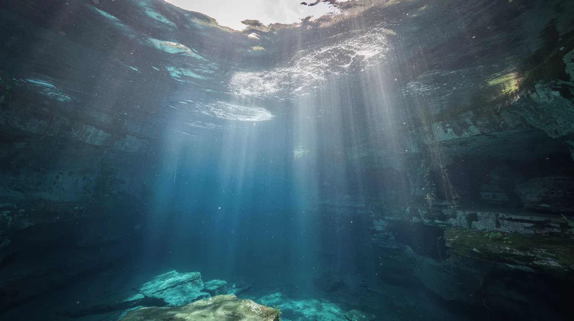
Temperature: Crystal clear water maintained at 24-25°C year-round
Clarity: Visibility often exceeds 30-40 meters in undisturbed areas
Structure: Cenotes serve as vertical entrances while horizontal tunnels form the river-like passages
Essential terms to understand:
Cenote - Natural sinkhole exposing groundwater, from Maya “dzonot” meaning sacred well
Karst - Landscape formed by dissolution of soluble rock like limestone
Aquifer - Underground layer of permeable rock holding groundwater
Halocline - Visible boundary layer between freshwater and saltwater
Geology and Hydrology of the Yucatan Aquifer
The Yucatan Peninsula is essentially a flat limestone platform formed from ancient marine sediments that once lay on the sea floor millions of years ago. Rainwater, slightly acidic from dissolved carbon dioxide, slowly dissolves this porous rock over millennia, creating an ever-expanding maze of underground caves and passages.
The peninsula lacks surface rivers because precipitation infiltrates directly into fractures and caves. Water travels through the system at speeds of 1-2 km per day, eventually discharging into the Caribbean Sea through submarine springs.
The aquifer contains a density-stratified structure: lighter freshwater from rainfall floats atop denser underlying seawater, separated by a visible mixing layer. Think of it like oil floating on water—two liquids that don’t fully mix due to different densities.
Extent and Major Underground River Systems
Quintana Roo on the Caribbean coast hosts some of the world’s longest mapped underwater cave systems. Since the 1980s, cave diving expeditions have steadily expanded our understanding of these passages, with new discoveries adding kilometers annually.
Major systems by mapped length (as of recent surveys):
Sistema Ox Bel Ha – Exceeds 435 km, currently the world’s longest underwater cave
Sistema Sac Actun – Over 370 km of passages near Tulum
Sistema Dos Ojos – Connected to Sac Actun in 2018, featuring spectacular caverns
Many systems begin deep inland and extend toward the coast, discharging freshwater directly offshore. This contrasts with northern Yucatan around Mérida, where vertical shafts predominate rather than the long horizontal passages found along the Riviera Maya.
Freshwater–Seawater Interface and the Halocline
The halocline represents one of the most striking features divers encounter in these systems. At depths typically between 10-30 meters near the coast (deeper inland), a sharp boundary separates lighter freshwater above from heavier saltwater below.
This stratification matters because it:
Controls water quality throughout different depths
Influences flow direction within the aquifer
Creates specialized habitats for unique microorganisms
Can transport contaminants rapidly from inland sources to the sea
One point of particular geological significance: cenotes aligned along the rim of the Chicxulub impact crater—formed 66 million years ago when an asteroid struck—mark a ring approximately 200 km in diameter where fracturing enhanced groundwater flow and cave development.
Cenotes: Gateways to the Underground Rivers
Cenotes function as natural entrances to the underground river network. When cave roofs collapse, they expose the groundwater below, creating pools that range from small openings to vast swimming areas.
Main cenote types:
Open cenotes – Wide surface pools fully exposed to light, ideal for swimming and snorkeling
Semi-open cenotes – Partially roofed with some areas in darkness
Cavern cenotes – Small openings leading to large underground chambers
Closed cenotes – Deep vertical shafts requiring specialized equipment
Cenote water clarity attracts photographers, snorkelers, and divers from around the world. Specific cenotes provide access to major underground rivers:
Cenote Dos Ojos near Tulum connects to the massive Sac Actun system
Access cenotes for Ox Bel Ha are located south of Tulum
Gran Cenote offers beginner-friendly cavern diving experiences
Maya Culture, Rituals and Cenotes
The Maya believed cenotes were sacred places—portals to Xibalba, the underworld—and homes of Chaac, the rain god. In a peninsula without surface rivers, these permanent water sources determined where cities could thrive.
Major settlements like Chichén Itzá developed around cenotes. The Sacred Cenote there has yielded remarkable archaeological finds:
Jade ornaments and gold artifacts dating back over a thousand years
Ceramic vessels used in ritual offerings
Human remains from sacrificial ceremonies
Beyond ritual significance, submerged caves preserve evidence of early humans in the Americas. The skeleton known as “Eve of Naharon,” discovered in Naharon Cenote, dates to approximately 13,000-13,600 years ago—pushing back the timeline of human presence in this region.
These discoveries blend scientific wonder with cultural heritage, reminding visitors that cenotes carry deep meaning beyond their geological features.
Rio Secreto and Other Accessible Underground Rivers
Rio Secreto offers one of the best opportunities to experience a Yucatan underground river without specialized diving training. Located near Playa del Carmen and opened for ecotourism in 2007, this partially flooded cave system allows visitors to walk and wade through shallow sections while swimming in crystal clear pools.
Unlike fully submerged systems requiring technical scuba diving equipment, Rio Secreto’s passages range from ankle-deep to chest-deep, making them accessible to most visitors. The cave features stunning speleothems—stalactites hanging from above, stalagmites rising from below, and columns where they meet—formed over tens of thousands of years.
Conservation-focused management includes:
Small group sizes (maximum 10-12 people)
Mandatory trained guides
No-touch rules for all formations
Bans on sunscreen and insect repellent to prevent chemical pollution
Provided wetsuits and helmets
Visitor Experience in Yucatan Underground Rivers
Walking through an underground river creates a sense of wonder unlike most surface experiences. The journey typically involves:
Wading through ankle- to chest-deep water in narrow passages
Short swimming sections in deeper pools
Moments of total darkness when guides switch off lights
Silence broken only by dripping water echoing through chambers
The environment stays cooler than the jungle above—around 24°C—providing relief from tropical heat. Light beams entering through cenote openings create dramatic shafts piercing the darkness, while walls display millions of years of geological history.
Safety measures:
Trained guides lead all tours
Life jackets available for non-swimmers
Age minimums (typically 6+) and health checks
Clear instructions for navigating the fragile space
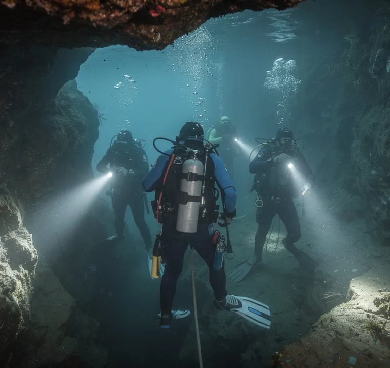
For fully flooded systems, exploration requires certified cave diving credentials. This isn’t recreational scuba diving—it demands specialized training, equipment like guideline reels, and experience navigating environments where fear must be controlled and distance from the entrance calculated precisely.
Microbial Life and Scientific Research in the Underground Rivers
Beyond their scenic appeal, Yucatan’s underground rivers serve as living laboratories. In the lightless depths of these flooded caves, unique microbial communities thrive in conditions that would challenge most life forms.
Research campaigns, including 2019 expeditions led by Northwestern University, have sampled water from deep caves and cenotes along the Riviera Maya. Using DNA sequencing, scientists discovered that microbial community composition shifts based on:
Cave type and structure
Distance from the sea
Presence of haloclines
Local environmental conditions
Key bacterial groups like Comamonadaceae play important roles in nutrient cycling, organic breakdown, and natural pollutant attenuation—essentially helping the aquifer clean itself.
Why Microbial Communities Matter
These microorganisms aren’t just scientific curiosities. They help:
Break down organic matter entering the groundwater
Transform nutrients like nitrogen and phosphorus
Naturally attenuate some pollutants before they spread
Maintain the aquifer’s self-purifying capacity
When contamination disrupts these communities, the aquifer loses its natural cleaning ability. Clear waters can turn greenish and turbid as nutrient influx fuels unwanted growth.
The connection to human life is direct: millions of residents and tourists rely on this groundwater for drinking water, agriculture, and tourism. Healthy microbial communities provide hope for natural resilience, but they have limits—severe pollution overwhelms their capacity.
Threats to Yucatan’s Underground Rivers
The same porous limestone that creates these magnificent underground rivers also makes them highly vulnerable. Contaminants entering the system travel rapidly through caves and fractures, bypassing soil filtration that protects other aquifers.
Major pollution sources:
Untreated or poorly treated sewage from rapidly growing coastal towns
Agricultural runoff carrying fertilizers and pesticides
Landfill leachate seeping into groundwater
Industrial discharges entering the permeable bedrock
Pollutants can travel from inland sources to coastal reefs in just 2-3 days. Nutrient-rich groundwater discharges fuel algal blooms that smother coral along the Mesoamerican Barrier Reef and destroy seagrass meadows critical to marine life.
Infrastructure Projects and Land-Use Change
Large infrastructure projects raise significant concerns for aquifer protection. The Tren Maya railway, particularly sections routed through Quintana Roo’s fragile karst, has sparked environmental debate.
Documented risks include:
Steel pilings driven into cave systems causing structural damage
Vibrations potentially collapsing thin cave roofs
Cement and construction materials entering groundwater
New contamination pathways created by excavation
Rapid urbanization along the Cancún-Tulum corridor compounds these pressures. Hotels, roads, and resorts built directly over the aquifer increase impermeable surface and contamination risk.
Deforestation for agriculture and real estate development removes vegetation that naturally slows and filters rainfall before it enters the underground rivers. Each cleared hectare reduces the system’s natural protection.
Protecting Yucatan’s Underground Rivers
Effective conservation remains possible. The challenge requires combining science, regulation, and local stewardship in ways that acknowledge both environmental and economic realities.
Key protection strategies:
Improved wastewater treatment facilities in coastal communities
Strict controls on chemical use near recharge zones
Careful planning of infrastructure projects in karst areas
Establishment and enforcement of protected areas
Monitoring by speleological groups and local communities
Tourism best practices play a crucial role. Operators like Rio Secreto demonstrate that underground river access and conservation can coexist through limited group sizes, no-touch rules, and bans on harmful chemicals.
Visitors can contribute by choosing responsible operators, respecting cultural protocols around sacred places, reducing plastic use, and accepting that some experiences require leaving products like sunscreen behind.
Future Research and Monitoring
New passages are discovered every year—mapping the full extent of these systems remains an ongoing project. Technological tools advancing this work include:
Underwater mapping equipment carried by cave divers
Drone-based sinkhole detection for identifying new entrances
Environmental DNA (eDNA) sampling to track biodiversity
Long-term monitoring programs tracking contaminants and water levels
Collaboration between universities, government agencies, NGOs, and cave diver communities provides the most comprehensive approach. Understanding these underground rivers more deeply is the prerequisite for managing them sustainably as climate change and development pressures intensify.
Planning a Visit to Yucatan’s Underground Rivers
Common bases for exploring underground rivers include Playa del Carmen, Tulum, and Valladolid—each offering different access points and experiences.
Typical activities:
Rio Secreto tours - Beginner - Walking, wading, swimming with guides
Cenote snorkeling - Beginner - Surface exploration in open cenotes
Cavern diving - Open Water certified - Guided dives within light zone
Cave diving - Cave certified - Technical exploration in flooded passages
Essential etiquette:
Always go with licensed guides
Respect no-touch rules absolutely—formations took millennia to grow
Avoid sunscreen and insect repellent before entering the water
Never remove anything from caves
Follow guide instructions without exception
The dry season (December-May) typically offers better water clarity, while the rainy season (June-November) can reduce visibility with surface runoff.
Operators provide helmets, life vests, and wetsuits. Bring a towel, change of clothes, and a passion for experiencing one of nature’s most remarkable hidden environments.
These underground rivers represent far more than a tourist attraction. They’re the lifeblood of an entire region—supporting ecosystems, providing drinking water, and connecting modern visitors to a world the Maya considered sacred. Your moment in these waters can contribute to their protection or their decline. The choice lives in every decision you make before, during, and after your journey underground.

Secure Your Spot in History. Easy Booking, Instant Confirmation, 100% Adventure.
100% Secure Booking - Official 2026 Ticket Links | Your Gateway to the Maya World: Secure Tickets, Expert Guides, Unforgettable Memories.
© Yucatantickets.com 2026
All rights reserved. Privacy Policy. Terms and Conditions.